Showing posts with label map. Show all posts

06 January 2014

Land Plat for the Heirs of Daniel Crapps

     This is a plat showing the land of Daniel Crapps of Lexington County, South Carolina and how it was deeded to his heirs at the time of his death in 1867.  My 3rd Great Grandmother, Julia Crapps Leaphart, had already passed away when her father died, so her land is marked (section A) for her heirs.


     I'd love to find out exactly where this land was, and there are some clues.  Unfortunately, I haven't been able to identify the rivers, even using old maps.  I think if I really want to find the location, I should find deeds and estate records for all of the neighbors shown on the map.  Those might hold more geographical clues.

15 November 2013

Can You Draw the US?

     First, if you haven't seen it yet, check out this post over at BuzzFeed where people attempt to draw the United States from memory.  It's pretty funny.  No seriously, check it out 'cause it'll make my attempt look a little better.

     I decided to give it a try and this is what I came up with:

     So I started with what I know: the South East.  However, when I started to draw North Carolina, it turned into Virginia and NC got left out.  That's really the only thing that I'm confused about why I got it wrong.  From there, I moved west, where I ran out of paper.  Then did the North East and Mid-West separately, but wasn't quite able to connect them to the rest of the country (which lead to a couple of "states" named "oops."  I completely forgot Wyoming, Nebraska and Wisconsin.  I couldn't figure out where Indiana went and I knew I was putting Iowa in the wrong place, but couldn't figure out where it actually went.  I got some other stuff in the wrong places, but in their general vicinity. Honestly though, I'm kinda happy with how well I did and that I didn't cheat!

     So my challenge to you is to try this on your own.  How well can you do?


10 November 2013

My Limited Travels

     There's a meme going around Facebook right now featuring this map.  You can customize it to reflect your travels.  Many of the maps I've seen shared amongst fellow genealogists are much more colorful than my own!  Hopefully one day my map will be more colorful.

Color Key:

  • Red means I've just passed through, maybe seen a thing or two.
  • Amber means I've at least slept there and seen a few things. I have a first-hand idea of what the state is like.
  • Blue means I've spent a good amount of time in that state.
  • Green means I've spent a lot of time in that state, weeks at at time on multiple visits – or lived there.

13 May 2013

Connecting With Civil War Ancestors Through Battle Maps

     Last week was the 150th anniversary of the Battle of Chancellorsville, a Civil War Battle fought in Virginia.  I know, from reviewing service records and researching regiment information, that my ancestors, Nathan Hyler and Frank Leaphart, fought at Chancellorsville with South Carolina's 15th Infantry Regiment, Company C.

     So I know that they were there, but what does that really mean?  Many of the battles fought in the Civil War were very large, involving troops from all over the country.  Where were my ancestors?  I'm a visual person, so when my google searching brought me to CivilWar.org's battle maps, I was able to really connect with and better understand what role my ancestors played in the battle.

     Take for example, this map of the Battle of Chancellorsville.  It's only a small piece of this map, which shows geographical features, modern day roads and historic troop movements.  I can see the 15th at the back of Kershaw's Brigade, moving parallel to VA State Highway 3.  If I were to visit Chancellorsville National Battlefield Park, I would be able to locate the exact location where my ancestors fought.


     Different battles have different maps. Some are contemporary to the time period, some have different levels of details, some represent specific times during the battle, or some have special features such as 360° views.  But all of the ones I've viewed have had maps like the one above, which I find the most helpful.  The maps can be found by browsing and searching from the maps page, or from the specific battlefield page.  If you've signed up for a free account, you can download copies of the maps in PDF form.  I recommend doing this, because you can't zoom on the website.

     From now on, when I visit a Civil War Battlefield where my ancestors fought, I plan to take a copy of one of these maps with me.  Finding that personal connection to history is what genealogy is all about to me, and these maps bring me one step closer to my ancestors.

30 October 2012

Mapping the Genealogy Journey

     Even with my ancestors sticking to a pretty centralized locations in Georgia and South Carolina, it can be difficult to keep track of their locations.  To stay organized, I add locations of homes, cemeteries, and libraries in Google Earth.  It's really easy to do and is saved to my desktop.

     Aside from being a database of their locations, it also becomes a map of my travels. The map below shows only the locations that I've personally been to in my genealogy journey.  It's interesting to me that I've been so many places, but many are still very close to home. By driving only an hour or two I can go back in time 300 years. Thanks for not traveling very far Ancestors! 


08 February 2012

"My Georgia Ancestors" Map

     I've been looking for a project for my wall, something that would showcase my ancestors on a map.  I wanted something that could be broken down and moved without too much fuss if necessary. I did a google image search yesterday for "genealogy map project" and found the perfect idea.  Today I created my own version of this idea using a map of Georgia pasted to a foam board. It's still a work in progress, but I'm really excited about it and wanted to post it. I'm also planning on doing one for South Carolina.

Georgia Ancestor Map

24 February 2011

Cutest Map Ever!

     I went down to the Georgia Archive again today. I really wish I lived closer and gas were cheaper, but every trip is worth it. Today I remembered to take my flash drive and was able to save 1GB worth of microfilm scans to it. I concentrated on finding deeds and mortgages for my Albea ancestors that I'd located in an index last time. These documents still confuse me and I've yet to find one for my ancestors that has a plat or map drawn on it, which I would love to see.

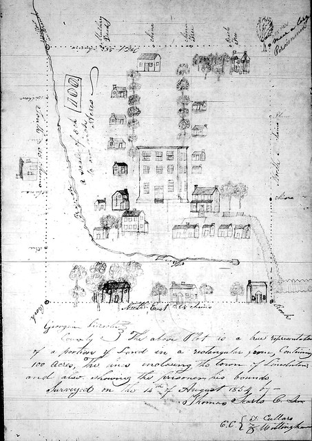
     However, I did find what is possibly the cutest map (plat) ever. I was browsing through the "Georgia Cities" card index and found a random note saying a map of Lincoln County was located in drawer 119, box 10. Here's the map, complete with little trees and houses and a river. I look at this drawing and think that my Great-Great-Great Grandfather lived on a farm nearby and would have visited these streets.


Lincolnton, Ga - 1854

04 December 2009

Google Streetview vs. Bing Streetside

Microsoft has a new map program: Bing Maps. It's much like Google maps and even has its own street view, called streetside. Although this app is still in Beta, it looks pretty promising. Much like when Google's streetview first started, streetside is very limited in coverage. But, from a quick review, the images available are better than those from Google.

For example, viewing Oakland Cemetery in Atlanta from Memorial Drive SE:

Google:


Bing:


I could go into detail about how to use Bing maps, but if you are familiar with Google maps, you'll figure it out quickly. Just click on the little blue man at the bottom middle of the screen and you can take it from there.

I'm hoping that Bing maps might provide new views or clearer images of areas I'm looking for. Also, a little competition might encourage Google to improve some of their images.

20 October 2009

Historic Georgia Maps

As part of the Georgia Virtual Vault, the GA Secretary of State's office has put historic Georgia Maps online. There are maps of 161 GA counties (some no longer in existence) that date from 1866-1935. You can browse a list of maps, or search the database in categories such as title, publisher, year, notes, etc.

The maps are available in high resolution and individuals can use the maps themselves as long as they give credit. For each map, there is a usually a bit of information about it's creation.

Map of Emanuel County, GA, cir. 1886:


27 April 2009

GA Sanborn Fire Insurance Maps

A valuable resource for those researching in Georgia, is the Sanborn Fire Insurance Map Collection. The collection is made up of colorful maps from 1867-1970 that depict mostly cities and town from across the county.

The Georgia collection is available online from two sources: Sanborn Fire Insurance Maps, 1884-1922 (Free) and Digital Sanborn Maps, 1867-1970 (ProQuest subscription required).

Navigating the images is made easy by an "index" map. When viewing a city's index map, you can click on a part of that map to view a particular section of the city. You can navigate from section to section, exploring streets and buildings. Streets will include address numbers and buildings may include information about the business, building materials, number of floors and any other information that might be of importance to firemen. Make sure to check out the map's Key, Seal and Index page for more information.

For example, see: Elberton, GA in 1885 and 1922. In 1885, according to the seal there was a population of 1,000, no Steam or Hand Engines and water facilities were "not good." By 1922 there was a population of 7,000 with 4 firemen on duty at all times and a detailed description of a complex water system. This can be very valuable information for understanding where our ancestor came from.

22 April 2009

Georgia County Formation

The state of Georgia has 159 counties - the most of any state west of the Mississippi River and the second most in the US. These counties seem to be ever changing (want to bring Milton County back?) and have a long history of creation.

When searching for ancestors, you often have to know what county they lived in, in order to search the correct census, court house or archive. It also helps to have alternative places when you hit a brick wall. If you're having trouble figuring out which county your county was created from and when, check out the Georgia Formation Maps at FamilyHistory101.com. It's a pretty neat slideshow that could help Georgia researchers quite a lot.

29 March 2009

A Weekend Link - Maps

I love maps, so I like this site. Reinhold Berg Antique maps is a site that sells antique maps. Their website has a large collection of maps from around the world. The maps are organized geographically and then chronologically, so it's easy to find a map of the time and place that you're looking for. You can also zoom in on each map, which is great and something you can't always do at other sites. And, if you've got lots of money, you can even buy the maps.

06 January 2008

I'm planning a genealogy/vacation to South Carolina. I've got three cemeteries on my list in Greenwood and the surrounding area. I've found the location of two of them, but I still need an exact location on the third one.

1. Edgewood Cemetery - in downtown Greenwood, the burial place of William A. Albea and Nina Sprouse Albea.

2. Bethel Methodist Church Cemetery - burial location of many Dorn, Witt, and Quattlebaum ancestors. Also supposed to be the burial place of Charles Ray Albea - though he's not listed on the cemetery transcription.

3. Quattlebaum Family Cemetery - This is the one where I'm not sure of the exact location. It's supposed to be on HWY 67 on the Greenwood/McCormick County line.

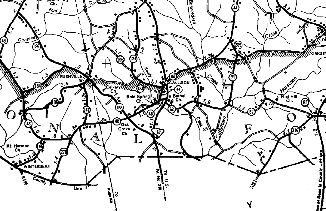
I was having a hard time locating the Bethel Methodist Church until I found a link to a handy website on findagrave.com. It's got DOT maps to multiple states, including Georgia and South Carolina. There are listings for a lot of cemeteries and churches, including Bethel.

Bethel Meth Church

LinkWithin

Related Posts with Thumbnails